Department of Geodetic Engineering: Difference between revisions
| Line 4: | Line 4: | ||
The Department of Geodetic Engineering celebrates 72 years of national significance and noteworthy service to the Filipino people, providing not just unparalleled academic quality in the fields of geodesy and geomatics, but also providing public service through technical training and relevant research. Since its formal establishment in 1937, the department has continuously been upgrading its resources, through constant faculty training and facility improvement to correspond to the changing demands of the country and the international arena. With the center of excellence in geodetic engineering bestowed upon the department in 1999, the department has maintained its status as the country’s focal point in advancing the science of geodetic engineering for national development and the pursuit of academic excellence. From its humble beginnings of being simply measurement science, the department has reinvented and developed the surveying profession and has led the charge in promoting geo-informatics and advance geo-spatial analysis in the country.<br /> | The Department of Geodetic Engineering celebrates 72 years of national significance and noteworthy service to the Filipino people, providing not just unparalleled academic quality in the fields of geodesy and geomatics, but also providing public service through technical training and relevant research. Since its formal establishment in 1937, the department has continuously been upgrading its resources, through constant faculty training and facility improvement to correspond to the changing demands of the country and the international arena. With the center of excellence in geodetic engineering bestowed upon the department in 1999, the department has maintained its status as the country’s focal point in advancing the science of geodetic engineering for national development and the pursuit of academic excellence. From its humble beginnings of being simply measurement science, the department has reinvented and developed the surveying profession and has led the charge in promoting geo-informatics and advance geo-spatial analysis in the country.<br /> | ||
The department currently boasts of five laboratories for surveying, photogrammetry, GIS applications, remote sensing, and applied space technology research, which some are now under-going renovation and upgrading. Through cooperative consortium and association with various government agencies and some private practitioners, the department is able to acquire state-of-the art equipment and instruments that have been used to better simulate the practice of the profession and advance the level of research capabilities of the department. <br /> | The department currently boasts of five laboratories for surveying, photogrammetry, GIS applications, remote sensing, and applied space technology research, which some are now under-going renovation and upgrading. Through cooperative consortium and association with various government agencies and some private practitioners, the department is able to acquire state-of-the art equipment and instruments that have been used to better simulate the practice of the profession and advance the level of research capabilities of the department. <br /> | ||
[[Image:GE3.jpg|200px|thumb|left]] | |||
In recent years, the department has embarked in more challenging and nationally significant endevours to increase the relevance of the department in nation-building. Since 2007, the department has been working very hard in the Land Administration and Management Project Phase 2 (LAMP2) for the advancement and upgrading of land management in the country. In February of 2008, the department signed a Memorandum of Agreement with NAMRIA for several research projects in aid of the implementation of Philippine Reference System of 1992. Through this agreement, NAMRIA will finance four key research components to establish the needed guidelines and standards to be used in various survey techniques, which will aid in the full implementation of PRS92 as the country’s national geodetic reference. The department shall be providing the technical expertise and lead the survey works in the research. Since April of 2008, the department has been working tirelessly with the Institute of Philippine Real Estate Appraisers (IPREA) gearing towards the institution of Value Engineering, specifically on the real-estate valuation. This move aims to professionalize the field of valuation and to infuse technical research in the industry. <br /> | |||
[[Image:GE1.jpg|200px|thumb|left]] | [[Image:GE1.jpg|200px|thumb|left]] | ||
The department has also started to work closer with the Geodetic Engineers of the Philippines (GEP), the country’s sole authorized professional organization for geodetic engineers. The industry has also been tapped to facilitate out-of-the-classroom learning experience through the OJT program in the curriculum, which saw 11 graduating GE students becoming trainees in various companies and organizations namely: DMI Consultants, RASA Surveying and Realty, FF Marine Corporation, Geodata, and TAO Pilipinas . This closer relations with the GEP and the industry not only aims to better equip the students with the expertise and practical know-how needed by today’s workforce, but also to contribute in professionalizing the practice and infusing more research thrust in the industry. <br /> | The department has also started to work closer with the Geodetic Engineers of the Philippines (GEP), the country’s sole authorized professional organization for geodetic engineers. The industry has also been tapped to facilitate out-of-the-classroom learning experience through the OJT program in the curriculum, which saw 11 graduating GE students becoming trainees in various companies and organizations namely: DMI Consultants, RASA Surveying and Realty, FF Marine Corporation, Geodata, and TAO Pilipinas . This closer relations with the GEP and the industry not only aims to better equip the students with the expertise and practical know-how needed by today’s workforce, but also to contribute in professionalizing the practice and infusing more research thrust in the industry. <br /> | ||
The student population now reaches 120 undergraduate students and 60 graduate students. Each one is given the opportunity to excel in both academic and extra-curricular activities, with aactual fieldwork and research projects provided for under the close guidance from the faculty. Last semester, 12 students were able to successfully defend their theses, which they later presented in symposiums including the GEP-NCR annual convention. And with the regular evaluation and updating of the curriculum, GE students are secured that their learning will lead them to become successful geodetic engineers when they graduate.<br /> | The student population now reaches 120 undergraduate students and 60 graduate students. Each one is given the opportunity to excel in both academic and extra-curricular activities, with aactual fieldwork and research projects provided for under the close guidance from the faculty. Last semester, 12 students were able to successfully defend their theses, which they later presented in symposiums including the GEP-NCR annual convention. And with the regular evaluation and updating of the curriculum, GE students are secured that their learning will lead them to become successful geodetic engineers when they graduate.<br /> | ||
Revision as of 12:25, 31 March 2009
DEPARTMENT OF GEODETIC ENGINEERING

The Department of Geodetic Engineering celebrates 72 years of national significance and noteworthy service to the Filipino people, providing not just unparalleled academic quality in the fields of geodesy and geomatics, but also providing public service through technical training and relevant research. Since its formal establishment in 1937, the department has continuously been upgrading its resources, through constant faculty training and facility improvement to correspond to the changing demands of the country and the international arena. With the center of excellence in geodetic engineering bestowed upon the department in 1999, the department has maintained its status as the country’s focal point in advancing the science of geodetic engineering for national development and the pursuit of academic excellence. From its humble beginnings of being simply measurement science, the department has reinvented and developed the surveying profession and has led the charge in promoting geo-informatics and advance geo-spatial analysis in the country.
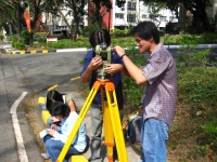
The department currently boasts of five laboratories for surveying, photogrammetry, GIS applications, remote sensing, and applied space technology research, which some are now under-going renovation and upgrading. Through cooperative consortium and association with various government agencies and some private practitioners, the department is able to acquire state-of-the art equipment and instruments that have been used to better simulate the practice of the profession and advance the level of research capabilities of the department.

In recent years, the department has embarked in more challenging and nationally significant endevours to increase the relevance of the department in nation-building. Since 2007, the department has been working very hard in the Land Administration and Management Project Phase 2 (LAMP2) for the advancement and upgrading of land management in the country. In February of 2008, the department signed a Memorandum of Agreement with NAMRIA for several research projects in aid of the implementation of Philippine Reference System of 1992. Through this agreement, NAMRIA will finance four key research components to establish the needed guidelines and standards to be used in various survey techniques, which will aid in the full implementation of PRS92 as the country’s national geodetic reference. The department shall be providing the technical expertise and lead the survey works in the research. Since April of 2008, the department has been working tirelessly with the Institute of Philippine Real Estate Appraisers (IPREA) gearing towards the institution of Value Engineering, specifically on the real-estate valuation. This move aims to professionalize the field of valuation and to infuse technical research in the industry.

The department has also started to work closer with the Geodetic Engineers of the Philippines (GEP), the country’s sole authorized professional organization for geodetic engineers. The industry has also been tapped to facilitate out-of-the-classroom learning experience through the OJT program in the curriculum, which saw 11 graduating GE students becoming trainees in various companies and organizations namely: DMI Consultants, RASA Surveying and Realty, FF Marine Corporation, Geodata, and TAO Pilipinas . This closer relations with the GEP and the industry not only aims to better equip the students with the expertise and practical know-how needed by today’s workforce, but also to contribute in professionalizing the practice and infusing more research thrust in the industry.
The student population now reaches 120 undergraduate students and 60 graduate students. Each one is given the opportunity to excel in both academic and extra-curricular activities, with aactual fieldwork and research projects provided for under the close guidance from the faculty. Last semester, 12 students were able to successfully defend their theses, which they later presented in symposiums including the GEP-NCR annual convention. And with the regular evaluation and updating of the curriculum, GE students are secured that their learning will lead them to become successful geodetic engineers when they graduate.
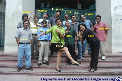
The department now boasts of its immensely talented faculty with varying fields of expertise, which have brought the learning process diversity in perspective, but with synergy in approach. Now being led by the new GE Department Chairman, Dr. Enrico Paringit, the following are the hardworking and dedicated men and women of the GE-Department:
Faculty: Prof. Epifanio Lopez, Dr. Rhodora Gonzales, Prof. Florence Galeon, Prof. Ariel Blanco, Prof. Oliver Macapinlac, Engr. Jessie Lynn Ablao, Engr. Louie Balicanta, Engr. Joanne Bisonaya, Engr. Alexander Caparas, Engr. Vanessa Dela Cruz, Engr. Matthew Oliver Ralp Dimal, Engr. John Louie Fabila, Engr. Darrel Alvin Ong, Engr. Ranel Padon, and Engr. Jeark Principe;
Lecturers: Atty. Amado V. Deloria and Prof. Juan G. Veracion
University Extension Associate Julius M. Bangate
Staff: Rodolfo Y. Isip, Elizabeth J. Villaflor, Edilberto B. Gabas and Alfredo C. Gorio
And to top them all, the department is very proud of the quality of the graduates it has produced. UP GE alumni have travelled long paths to success and have proven to be not only men and women of enormous aptitude, but more so have they proven themselves to be individuals of dignified and noble character.
And in the near future, the department plans to again undertake giant leaps that may revitalize and revolutionize not just the profession of geodetic engineering in the country, but the concept of spatial analysis and measurement science as we know it.


